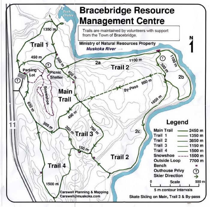
Bracebridge NRC

Hwy 11 - 5 km N. of Bracebridge
Posted on January 4, 2018 / 4714
Bracebridge NRC
X-Ski km : 16
Snowshoe km : 2
Skill Level : Easy, Intermediate
Terrain : small hills, wide paths, steep sections, flat sections
Facilities : parking, toilets/outhouse, food close by, trailhead map, good trail signage
Trail Fee : Free

Length –  16  km
Cross Country track set   –  16 km, cut your own
Skate Skiing  groomed  –  none
Snowshoe  trail –  1.5 km officially

Skill – Easy to Intermediate, beginners stay close to parking lot

Terrain –  mainly flat sections, incline to river, a few large hills

Hours – none set

Fee – free

Trail Map – good signage, paper maps at trailhead

Facilities – 2 parking lots, outhouse, 2 warming huts, benches

Highlights – Muskoka River, Duck Chutes, Bracebridge, High Falls

Phone – 705 645 3037

Website – Muskoka Trails Council

Current Conditions

Similar Trails – Muskoka, Whitchurch, Bendor

Local Clubs – Haliburton Nordic Ski Club, Arrowhead Nordic Ski Club

Access – Entry only when driving north on Hwy#11 on the eastside just north of Bracebridge. The entrance has only one sign right at the pull off from the highway, so watch for it. Two parking lots are 200m in forest. Note when leaving (it’s one way) you can only go north to the next cross over to get back to Toronto.


The Bracebridge Natural Resource Centre – BNRC is a forested area with a few wide trails that loop around and work their way down to the Muskoka River.

Though there is no official track set trail, volunteers are maintaining the trails somewhat so consider it rustic. There are enough skiers passing through that you will likely be able to use tracks from previous skiers.

The trails are all wide enough for Skate skiing but may get rather trampled in time. Try Main trail, Trail 3 and bypass.

BNRC is very convenient, right off the highway and free. Slow down for the turnoff on Hwy 11, easy to miss.

Not crowded but watch out for hikers, dogs and poops. Also it would be wise to dress in bright colours as hunting is allowed when in season.

The tracks by the parking lot start flat and if you avoid Trail 2 that goes to the river boundary the hills are few.

If you do Trail 2 along the river, it is rather pretty but you will have to deal with a monster hill on the south end. Walk it or climb it on skis, skiing down it would be a challenge.

Duck Chutes on the north Trail 1 is worth taking your skis off for a closer look.

Also on the other side of the highway, there is High Falls when you head south which is worth seeing. The picnic area is kind of closed in the winter for snowmobilers, so go to the Natural Resources Offices on the north side.

Opening Hours
  • Monday :None Set
  • Tuesday :None Set
  • Wednesday :None Set
  • Thursday :None Set
  • Friday :None Set
  • Saturday :None Set
  • Sunday :None Set

Bracebridge ski trail map

Reviews
3.5
Total Score 3 REVIEWS
Fun Factor: Scenic: Trail Design: Technical: Workout:
Leave a review
Fun Factor: Scenic: Trail Design: Technical: Workout: