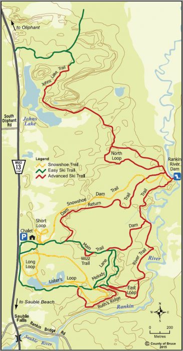
Sauble Falls has 18 km of Cross-Country ski trail and 14 km to Snowshoe on. It’s a beautiful, quiet place up by the Bruce Peninsula.
Many years ago the whole area was the sandy shores of Lake Huron, so what you are skiing on are ancient rolling dunes now covered over with evergreens and birches.
With terrain like this, the trails have many short hills/mounds just a meter or two in height, some steep. I found the paths fun as they were ever-changing, twisting and undulating over the terrain.
Being narrow and winding, most tracks are rated intermediate, and not wide enough to use Skate skis here.
For beginners, try the flat green loop – Melody Lane 2.8 km on the map. Beyond that, other paths are rather narrow and likely tricky for beginners to turn and climb up the mounds. (Though nothing here at Sauble is super technical or a grind to do.)
The Main Trail is a two-way route that is double-tracked set. All others are narrow one-way groomed loops.
Most trails lead you to the shelter at the dam on the Rankin River. It’s a worthy sight and good spot to rest & have a snack, before heading back another way.
Five separate new Snowshoe loops take you through the woods that are not too dense and are an interesting stomp.
On weekends and holidays the chalet is open, with friendly volunteers ready to help you and perhaps offer hot cider. Very basic services here – no gear rentals or snacks.
The chalet is warm and cozy but you may have to change in the car on weekdays.
Group skiing Mondays and Fridays at 10:30 a.m. starts from the chalet.
Though far for most, this is one of the best locations in S. Western Ontario to classic x-ski. Make it a weekend and try others in the area. The Georgian Bay coast gets the snow first (and plenty of it) by February.
Note – the actual Sauble Falls are not on the ski loops but by the bridge south on Hwy 13 just minutes away. In the winter they are beautiful to photograph.